Course Maps
Please proceed to Station Flats (Race Venue) to drop off your gear bag at the designated “bag drop” zone (not the bike racks). Next turn your car around and proceed 300m north to the Elbow Valley Fire Station Admin parking lot. Ride your bike back, set up your bike at an open spot on the bike racks in the transition zone (4 bikes alternating per section) and then pick up your race package at the tent.

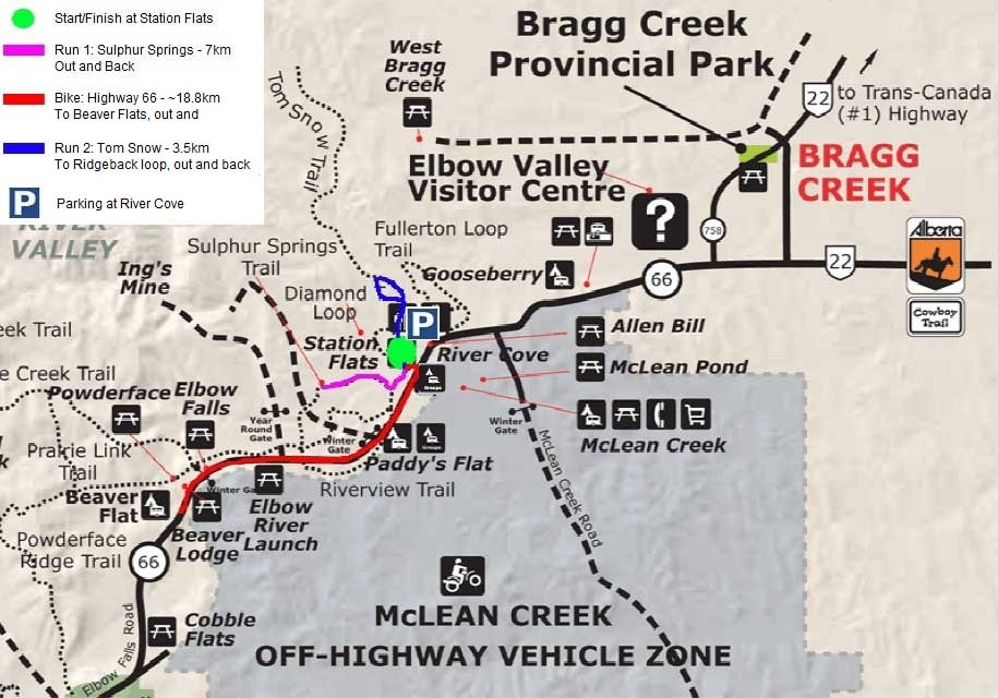
Leg 1: 7km Trail Run
The first leg of the race is a run out and back on the Sulphur Springs trail. This trail has 4 or 5 rolling hills but they are relatively short. The overall elevation gain is 159m, broken up over the 7k run. There is a shallow stream to cross and one section that often is a big mud hole covered with a few logs to help you cross, or you can run around it. Click the picture for an interactive map.

Transition Zone
You will return through the start/finish line arch into the transition zone. Proceed to your bike and remember to buckle up your helmet before taking your bike off the rack. It must remain on until you return and rack your bike. Walk your bike to the mount/dismount line and begin your ride.
TEAMS: Upon finishing the first run, simply “tag” your cyclist teammate at the bike rack. Cyclists then un-rack bike and proceed to the mount line to begin the cycle portion. Upon returning from the bike, cyclists dismount and return to the rack and tag their runner teammate. No transfer of bib number or timing chip is required.
Leg 2: 19km Road Bike
The bike course is out and back on Hwy 66 to Beaver Flat. It is paved highway with rumble strips and some loose gravel at certain sections. The bike route has a total elevation gain of 276m, mostly gaining in the first 9km. Once you hit the turnaround point, it’s a nice quick ride back to transition. Traffic will not stop for cyclists so proceed when with your turn around and entrance to Station Flats with caution. Click the picture for an interactive map.

Leg 3: 3.6km Trail Run
The last leg of the race is the most technical and consists of a loop on the Tom Snow trail/1st Ridgeback loop (clockwise). The Tom Snow has a few mud holes that you can run around, and the Ridgeback loop is definitely narrower with a hill. Elevation gain of 200m.
Important Notes: The run components of this race are on hiking/mountain bike trails so expect to see everything: rocks, roots, mud, gravel, logs, streams, and holes. The top of this loop is navigated clockwise (follow the signs).
There will be marshals on the highway to ensure you can cross the road safely at the turn around point and when re-entering Station Flats transition area, however they are unable to stop traffic so please keep your head up for vehicles and use caution. Click the picture for an interactive map.

Here is a larger area map for your reference.